
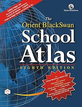
The Orient BlackSwan School Atlas – Eighth Edition
by Orient Blackswan Team
₹314
₹475
34% offYou save ₹161 • Tax included
Easy Return Policy
3-day return window from delivery for unused items in original packing. Read more
Delivery Method
Shipped via Indian Post, Pan-India coverage, typically 4-6 business days. Shipping policy
Delivery Charge
₹50 per book quantity, added at checkout. Flat ₹29 total for Dhanbad addresses.
Same Day Delivery (Dhanbad only)
Customers in Dhanbad can opt in for same-day delivery at checkout.
Customer Support
Need help with your order? Contact us
About
This completely updated, comprehensive and user-friendly edition of The Orient BlackSwan School Atlas brings the world closer to us through its maps and graphical representation of facts. The authoritative physical and political maps, as well as the maps covering climatic variations, geology, structure, soil types, vegetation and areas of human endeavour, such as agriculture, industry, communication and tourism, help students understand the relationship between geographical features and human activities. Key features: • detailed, up-to-date regional maps of India showing all twenty eight states and the eight union territories • a special map of India depicting natural disasters, flood-and drought-prone areas and paths of cyclonic storms • a map of India showing forest cover, national parks, sanctuaries, tiger reserves and biosphere reserves • a special map of India showing rich cultural and natural heritage sites • maps of India showing population, density of population, literacy and sex-ratio based on the 2011 census data • a map of India showing the distribution of major religions in the country • a unique map of India on space science together with a list of satellites launched since 1975 • three-dimensional histograms and pie graphs giving the latest statistical data for various states and union territories of India • maps of all the states and union territories of India indicating the latest districts and their headquarters • historical maps that introduce the student to the dynamic nature of social change in the world • a map showing the SAARC countries • detailed maps of the continents showing climatic regions and latest socio-economic data • maps of the polar regions indicating exploration and expedition routes as well as various research stations in the Antarctic • world maps showing the physical regions, types of environmental degradation, endangered heritage sites and distribution of important wildlife species • a special map of the world depicting the age of the earth's crust, tectonics, tsunamis, earthquakes, tropical storms, hot spots and volcanic eruptions • a map of the world indicating the routes of well-known explorers and adventurers • latest key statistics of the world, including the flags of the newly independent countries • dual index of around 8000 places and geographical features, including the most recent changes in the world
Product Overview
This completely updated, comprehensive and user-friendly edition of The Orient BlackSwan School Atlas brings the world closer to us through its maps and graphical representation of facts. The authoritative physical and political maps, as well as the maps covering climatic variations, geology, structure, soil types, vegetation and areas of human endeavour, such as agriculture, industry, communication and tourism, help students understand the relationship between geographical features and human activities. Key features: • detailed, up-to-date regional maps of India showing all twenty eight states and the eight union territories • a special map of India depicting natural disasters, flood-and drought-prone areas and paths of cyclonic storms • a map of India showing forest cover, national parks, sanctuaries, tiger reserves and biosphere reserves • a special map of India showing rich cultural and natural heritage sites • maps of India showing population, density of population, literacy and sex-ratio based on the 2011 census data • a map of India showing the distribution of major religions in the country • a unique map of India on space science together with a list of satellites launched since 1975 • three-dimensional histograms and pie graphs giving the latest statistical data for various states and union territories of India • maps of all the states and union territories of India indicating the latest districts and their headquarters • historical maps that introduce the student to the dynamic nature of social change in the world • a map showing the SAARC countries • detailed maps of the continents showing climatic regions and latest socio-economic data • maps of the polar regions indicating exploration and expedition routes as well as various research stations in the Antarctic • world maps showing the physical regions, types of environmental degradation, endangered heritage sites and distribution of important wildlife species • a special map of the world depicting the age of the earth's crust, tectonics, tsunamis, earthquakes, tropical storms, hot spots and volcanic eruptions • a map of the world indicating the routes of well-known explorers and adventurers • latest key statistics of the world, including the flags of the newly independent countries • dual index of around 8000 places and geographical features, including the most recent changes in the world
Key Highlights
- Verified product & secure checkout
- Fast delivery (location dependent)
- Replacement/return as per policy
Total
₹314
Qty: 1 / 5